|
SN-10 Newer Operating Features
Features and Improvements Implemented in Version 2.2x onwards of the SN-10 Operating System Software include:
- Anti Collision Interface with FLARM:
With Version 2.35 of the operating software and above it is now possible to directly connect the SN10 to a FLARM data stream, thereby accessing and displaying collision warning information directly in the SN10 main display.
A variety of other informationn sourced from FLARM data stream is also accessible including the ID of nearby aircraft, their height and relative speed.
- Club Operating Mode:
The SN10 is now two instruments in one, for both competition and club flying. SN10 Club Mode is suitable for use by pilots flying just for fun, requiring NO training before use. The Club mode comprises only 4 simple pages; a home page (including a final glide to home or to an alternate landing place), the super-reliable SN10 wind calculator page, a key settings input page, and a moving map display (incorporating airspace information if available).
This powerful instrument has suddenly become even easier to use. For more information on this new operating mode click here.
- Customisable Main Data Page:
For the experienced pilot, the Main Data page of the SN10 has always been one of its trade mark features, providing a comprehensive set of data on the one page, minimising page switching and hence head down time needed inside the cockpit. With Version 2.20 of the operating software and above it is now possible to build on this key feature by creating an information page completely customisable to suit the pilot's discretion.
Information items on this page can be featured either as a single font row or at double font height to create easier readability and to highlight key data elements on the page. Almost any information item or input variable that is available throughout the instrument can be accessed and added to this single page, again simplifying operation of the instrument in the air and hence reducing viewing and operating time.
- FAI Sector Option added to Moving Map display:
From Operating System Version 2.1x and above a Moving Map display feature was added (see below). With Version 2.20 an FAI Turnpoint Sector option has been added to this feature in addition to the existing Barrel (cylinder) style turnpoint representation.
As the aircraft approaches a turnpoint the Map Display can be zoomed in to reveal the detailed dimensions of the turnpoint format thus enabling the pilot to accurately navigate toward and around a turnpoint as the turnpoint itself becomes physically obscured by the nose of the aircraft. An optional setting allows the instrument to automatically alert the pilot and to switch the instrument to navigate the next leg of the task immediately the internal flight logger records a valid data point within the mandated turnpoint control zone. (To ensure logging accuracy when using this feature, please note that if an external flight logger is being used then the GPS data from the external data logger must also be supplied to the SN-10 to ensure both instruments are recording GPS data in synchronisation.)
The SN-10 Moving Map turnpoint feature can considerably reduce cockpit workload while negotiating turnpoints, however; PLEASE REMEMBER THAT NO AMOUNT OF COCKPIT INSTRUMENTATION ASSISTANCE CAN OBVIATE THE REQUIREMENT TO MAINTAIN CONSTANT VIGILANCE OUTSIDE THE AIRCRAFT AT ALL TIMES.
Recent Improvements Implemented in Version 2.1x and higher of the SN-10 Operating System Software include:
- Moving Map Display:
With Version 2.1x and above a new moving map feature has been added. The SN10 moving map shows the boundaries of airspace areas loaded into the currently selected site, and the currently selected task. Airspace boundaries are drawn with solid lines, and task legs are drawn with dotted lines. The map and task can be shown in 'North-Up' or 'Nose-Up' orientation. In 'Nose-Up' orientation, the map is rotated to match what you see out of the cockpit, and the glider is shown at the bottom of the screen. In 'North-up' orientation, true North is always at the top of the screen, and the glider is drawn in the middle of the screen (the glider is rotated to point in approximately your current direction).
In the lower right of the screen, an arrow pointing 'North' is drawn, just like on a printed map (true North, not magnetic). When the moving map is in 'North-Up' mode, the arrow will always point straight up. In 'Nose-Up' mode, the arrow will rotate as you turn.
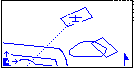
In the lower left of the screen, three fields are provided to zoom and scroll the map. You can scroll vertically or horizontally, and zoom from scales that show from 6km across the screen out to 200km across the screen. As you scroll, the glider will move from its normal position at the center of the screen (North-Up) or bottom of the screen (Nose-Up). Turnpoint cylinders or FAI Sector details are displayed if you zoom in on the task turnpoints. However no cylinder or line is displayed for the start and finish (international rules still in chaos on this point).
Return to top.
- Wind Calculation Upgrade:
The GPS-Wind-calculation is further improved. The SN10 accurately calculates the wind without any pilot interaction and without a compass. The new method is tried and tested to work even in flights without circling in thermals. In addition to the current wind velocity and direction, we show the current head/tailwind and the wind at different flight levels. Also we give an estimate of how reliable we believe the wind estimate will be.
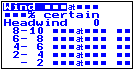
The height bands can be displayed in 500 metre increments or, as depicted here, in 2,000 foot increments (depending upon the height units preference setting).
- SN10 Database Upgrade:
We have changed the current internal database and site structure. The new software contains two parts:
(1) An optional data library together with a PC program to easily select the desired fields and turnpoints, or to enter your own additional points, and
(2) The SN10 database software supports 2 sites loaded in the instrument, with 600 and 900 points each. The information stored for each point (turnpoint, airfield, etc.) includes a 7 character name, coordinates, ICAO sign, attributes (landing field, etc.), elevation, plus an 80-character long description (the long description can be used for radio frequencies, runway lengths, etc.)
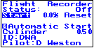
- New Flight Recorder (DataLogger):
The SN10 now has an inbuilt flight recorder capability, which records the details of your flight. The flight log is available (after data transfer to a PC) in IGC file format that can be read by a number of analysis programs, including StrePla, EWView, IGCView, and the Cambridge viewer software (v 5.6, NOT 5.5). The flight recorder data is embedded with a security (digital signature) which can be independently verified on an external PC using an IGC-compliant security checking utility program also included with the latest version of the operating software. As a consequence the resultant IGC flight data file is valid for Australian competition scoring verification purposes.
Return to top.
- Notification of turnpoint arrival:
The SN-10 provides an audible and visual notification of turnpoint arrival, plus automatic sequencing to the next leg of the task. At present the notification is limited to a cylinder style turnpoint zone. Coding for an FAI sector notification is in development. This feature should not be used if an external datalogger is feeding the SN10.
|
